Downtown Helena Multimodal and Infrastructure Plan

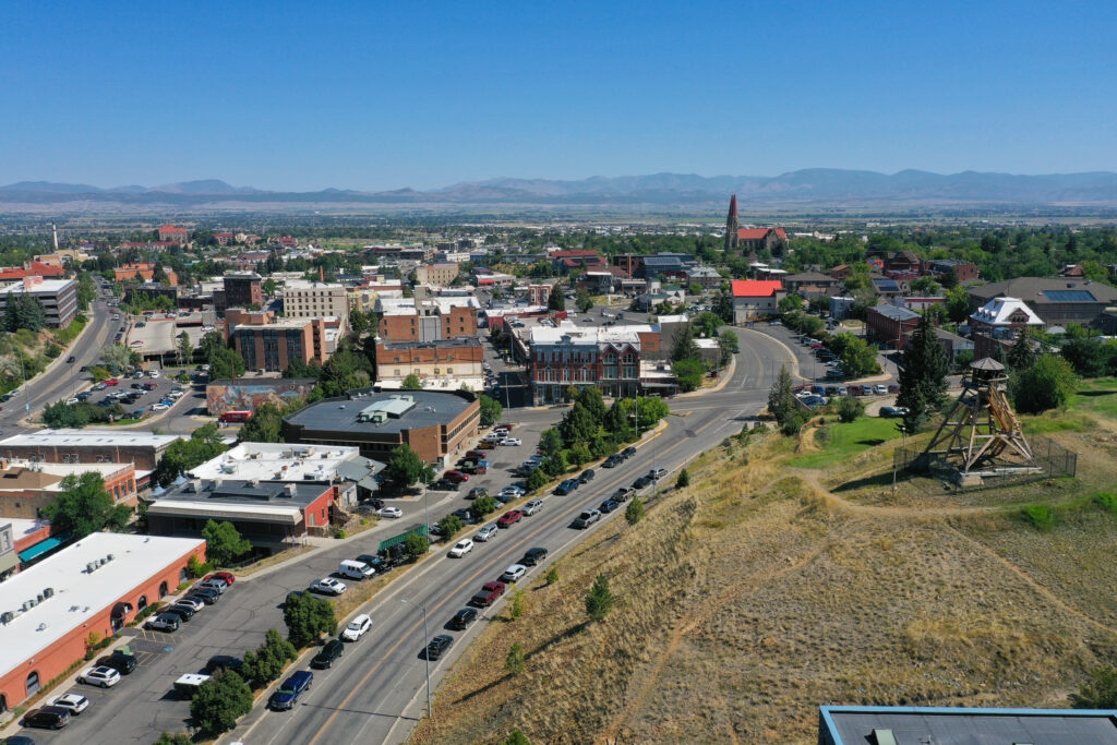
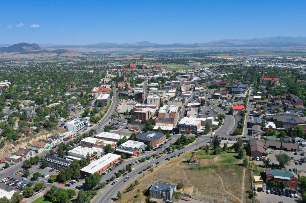
The City of Helena sought to develop a comprehensive strategy to enhance mobility, safety, and public infrastructure within its historic downtown core. RPA led preparation of the Downtown Helena Multimodal and Infrastructure Plan, creating an integrated vision to improve connectivity, support economic vitality, and balance the needs of all users. The plan evaluates existing transportation and infrastructure conditions and identifies opportunities to enhance the pedestrian, bicycle, transit, and roadway network while maintaining the character of downtown Helena. Emphasis was placed on improving accessibility, safety, and circulation, as well as supporting redevelopment and long-term resiliency of critical infrastructure systems.

Key Project Elements

Project Description

RPA conducted a comprehensive assessment of existing transportation and infrastructure conditions within downtown Helena, including roadway operations, pedestrian and bicycle connectivity, transit access, parking supply, and underlying utility systems. The analysis identified key constraints and opportunities to improve mobility, safety, and functionality in the downtown area.

A strong emphasis was placed on multimodal connectivity and user experience. RPA evaluated pedestrian crossings, sidewalk conditions, bicycle routes, and parking access to develop recommendations that enhance accessibility and create a more walkable and bike-friendly downtown environment. Circulation patterns and roadway configurations were analyzed to balance vehicular access with multimodal priorities.

Public and stakeholder engagement played a central role in shaping the plan. Outreach efforts included stakeholder meetings, public workshops, and interactive tools to gather input from residents, businesses, and community leaders, ensuring the plan reflects local priorities and supports downtown vitality.

The plan also integrated infrastructure considerations, including assessment of existing utilities and drainage systems, to align transportation improvements with broader infrastructure needs. Conceptual streetscape and urban design recommendations were developed to enhance the character and functionality of downtown corridors.

The final plan provides a coordinated set of recommendations, including prioritized projects, design concepts, and an implementation strategy to guide future investments. The plan positions the City of Helena to enhance mobility, improve safety, and support economic development while preserving the unique character of its downtown core.

Project Details​

Client

City of Helena

Location

Helena, Montana

Greater Helena MPO Long Range Transportation Plan

The Greater Helena Area transitioned into a newly designated Metropolitan Planning Organization (MPO), requiring a comprehensive and forward-looking approach to transportation planning. RPA led the development of the area’s Long Range Transportation Plan (LRTP), establishing a 20-year vision for a safe, efficient, and multimodal transportation system. The plan integrates roadway, transit, freight, bicycle, and pedestrian networks while aligning with regional priorities such as economic development, sustainability, and public safety. Supporting efforts included a Comprehensive Safety Action Plan (CSAP), a Public Participation Plan (PPP), and additional transit planning components ensuring a coordinated and community-driven planning process.

Key Project Elements

Project Description

RPA developed a comprehensive, data-driven planning framework to evaluate existing conditions and guide future transportation investments across the Greater Helena Area. The effort included a detailed needs assessment, incorporating analysis of existing plans, traffic operations, multimodal connectivity, and socioeconomic trends. Travel demand modeling was used to evaluate future conditions, identify system deficiencies, and support informed decision-making.

A robust public and stakeholder engagement program ensured the plan reflects community priorities. Outreach efforts included stakeholder interviews, public open houses, interactive mapping tools, and online surveys, providing multiple opportunities for input throughout the planning process.

RPA conducted scenario planning and alternatives analysis to evaluate different transportation investments under projected growth projections. These scenarios were tested using modeling tools to understand system-wide impacts and guide the development of recommendations.

The project also included development of a Comprehensive Safety Action Plan, incorporating crash data analysis, safety risk assessment, and targeted strategies to reduce fatalities and serious injuries across the multimodal transportation network. Additionally, RPA completed transit planning efforts, including development of a Transit Development Plan (TDP), Transit Asset Management (TAM) Plan, and Transportation Improvement Program (TIP), supporting long-term investment and coordination while aligning with federal requirements.

The resulting plan provides a comprehensive roadmap for the Greater Helena Area’s transportation system, including prioritized projects, policy recommendations, and a fiscally constrained implementation strategy, positioning the MPO to guide transportation investments, support regional growth, and enhance mobility and safety for all users over the next 20 years.

Project Details​

Client

Greater Helena Metropolitan Planning Organization

Location

Lewis & Clark County, Montana

Public Outreach

Project Website

Great Falls Area Long Range Transportation Plan

RPA developed the 2024 Great Falls Area Long Range Transportation Plan, providing the region’s Metropolitan Planning Organization (MPO) with a comprehensive blueprint for guiding transportation investments over a 20-year horizon. The plan balances federal compliance with evolving community priorities, addressing everything from roadway capacity and safety to transit, bicycle, and pedestrian infrastructure, as well as emerging needs like electric vehicle charging and transportation equity.

Key Project Elements

Project Description

RPA was retained to develop the 2024 Great Falls Area Long Range Transportation Plan, a federally required planning document that charts a course for the area’s multimodal transportation system over the next 20 years. The plan was developed in full compliance with the Bipartisan Infrastructure Law, which introduced new federal requirements, updated planning emphasis areas, and expanded funding opportunities for MPOs nationwide.

RPA led plan development through a three-phase process covering existing conditions, visioning, and recommendations, designed to ensure meaningful public input at each stage. Outreach included two public open houses, stakeholder interviews, an online survey that received 575 responses, an interactive commenting map that generated over 160 public comments, and coordination with neighborhood councils and partner agencies. This broad engagement helped ensure the plan reflects the priorities of Great Falls residents, including a strong desire for improved pedestrian and bicycle infrastructure, expanded transit service, and safer streets.

The technical work underlying the plan included a detailed assessment of the existing transportation network covering roadways, non-motorized facilities, transit services, goods movement, and asset conditions, as well as a comprehensive safety analysis of 8,567 reported crashes over a five-year period. RPA used a travel demand model developed for Cascade County to project transportation conditions to 2045 under multiple growth and network scenarios, identifying corridors and intersections likely to experience capacity and operational challenges as the region grows.

The resulting plan includes a prioritized, fiscally constrained menu of improvements spanning committed near-term projects, recommended investments through 2045, and a visionary long-term network. Recommended projects address roadway reconstruction, intersection improvements, bridge rehabilitation, sidewalk infill, and expanded bicycle facilities, totaling approximately $200 million in planned investments. The plan also establishes non-motorized recommendations for nearly 100 miles of new or improved walking and biking facilities, as well as transit goals focused on expanded service coverage, improved reliability, and better rider amenities. The Great Falls LRTP was adopted by the Policy Coordinating Committee in November 2024.

Project Details​

Client

Great Falls Metropolitan Planning Organization

Location

Cascade County, Montana

Public Outreach

Project Website

Greater Triangle Area Transportation Plan

The Greater Triangle Area Transportation Plan was developed to guide transportation infrastructure investments based on system needs and anticipated developments over the next 20 years. The Plan included the areas between Four Corners, Belgrade, and Bozeman where recent suburban development has occurred or is anticipated to occur in the future. The comprehensive plan provides a vision for county officials, staff, and residents to work together to develop innovative approaches to plan and implement a transportation system that will serve the community’s citizens well into the future.

Project Description

Gallatin County has experienced significant growth over the past 40 years. The county has consistently outpaced the population growth of other Montana counties. This growth can be attributed to the evolving economies of the county’s largest cities, Bozeman and Belgrade, the continued expansion of Montana State University in Bozeman, and in-migration resulting from the high quality of life that the county offers. As Gallatin County continues to grow, it is important to understand growth trends to properly accommodate and prepare for the county’s current and future transportation needs.

The last regional county transportation plan was completed in 2007 with more recent updates completed for the urban areas of Bozeman and Belgrade. A new, comprehensive look at the transportation system in the growing suburban area was needed to understand system needs and investment opportunities over the next 20 years.

The Greater Triangle Area Transportation Plan (GTATP) provides a comprehensive and integrated strategy for transportation infrastructure and service improvements within the greater triangle area between Bozeman, Belgrade, Four Corners, and Gallatin Gateway. The GTATP focuses on strengthened roadway connections to facilitate safe and efficient travel between these quickly growing communities within the county. The plan addresses regional transportation issues, overall travel convenience, traffic safety, sustainability, funding, and multimodal connections. The GTATP includes recommendations for short-term improvements as well as long-term modifications and capital improvements to major roadways.

The GTATP serves as a guide for development of and investment in the region’s transportation system in a comprehensive manner. The GTATP was developed through a collaborative approach with county, state, and city staff, elected officials, and local residents. The plan provides a blueprint for guiding transportation infrastructure investments based on system needs and associated decision-making principles. The GTATP integrates previously completed planning efforts, includes detailed analysis of existing and projected transportation conditions, incorporates meaningful input from citizens and local officials, and provides a framework for future efforts within the context of state and federal rules, regulations, and funding allocations.

Project Details​

Client

Gallatin County

Location

Galatin County, Montana